Đồng Văn Karst Plateau
Đồng Văn Karst Plateau
Đồng Văn Karst Plateau
Đồng Văn Karst Plateau
A unique UNESCO karst geopark combining majestic mountains, ancient history, and the culture of ethnic minorities.
Hà Giang
Geological Plateau
Trekking & Ethnoculture
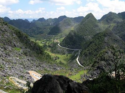
The Đồng Văn Plateau is a grand karst landscape spanning four districts of Hà Giang province: Mèo Vạc, Đồng Văn, Yên Minh, and Quản Bạ. About 80% of the territory consists of limestone that preserves the planet's geological history dating back up to 360 million years. This is a place where harsh natural beauty meets the centuries-old traditions of more than 17 ethnic groups, such as the H'Mông and Lô Lô.
- Duration
2–3 days
- Average budget
from $25
- Admission
10,000 ₫ (Pao's House)
- Current
20 °C, cool
- Best months
Oct – Aug
- Local language
Vietnamese, English
What you need to know
The Đồng Văn Plateau is famous for its breathtaking geological landmarks, such as the deepest Tu Sán Canyon (700-800 meters) and the majestic Mã Pí Lèng Pass. The northernmost point of Vietnam is marked here by the legendary Lũng Cú Flag Tower, reached by 389 steps.
Beyond nature, the region is a cultural gem. Visit "Pao's House" to experience the authentic daily life of local ethnic groups, or stroll through traditional markets. The Nho Quế River, with its turquoise waters, offers unforgettable boat and kayak rides. In 2025, the plateau was recognized as an outstanding cultural destination by the World Travel Awards.
October to December is the buckwheat flower blooming season. June to August is ideal for clear skies, trekking, and cloud photography.
On site
- How to get there
Car/motorbike from Hà Giang (140-150 km) via Route 4C
- Accommodation
Hotels from $15
- Local transport
Boat rental (50–150k ₫), private transport
- Cash
Essential
- Connectivity
4G, Wi-Fi in guesthouses
- With kids
Ok from 6+ years